Park and Portland safety improvements project
 Hennepin County is planning to make roadway improvements on Park Avenue (County Road 33) and Portland Avenue (County Road 35) between I-94 and 46th Street West (County Road 46). Construction is anticipated to begin in 2027 with dates subject to change.
As we prepare for this project, we want to hear about how you use Park and Portland avenues and how you think they should look in the future. Check back here for opportunities to provide feedback and updates about our plans for the corridor.
-
Upcoming safety improvements on Park and Portland avenues
Starting in 2024, we collaborated with community members to collect feedback on safety concerns, priorities, and intersections needing safety improvements. This feedback was incorporated into the design process. The project team is now finalizing the design details. Construction is anticipated to begin in spring 2027.
Project goals:
- Improve safety on Park and Portland avenues
- Enhance intersection crossings for people walking, rolling and biking
- Create protected spaces for biking
- Reduce vehicle speeds
Construction Overview:
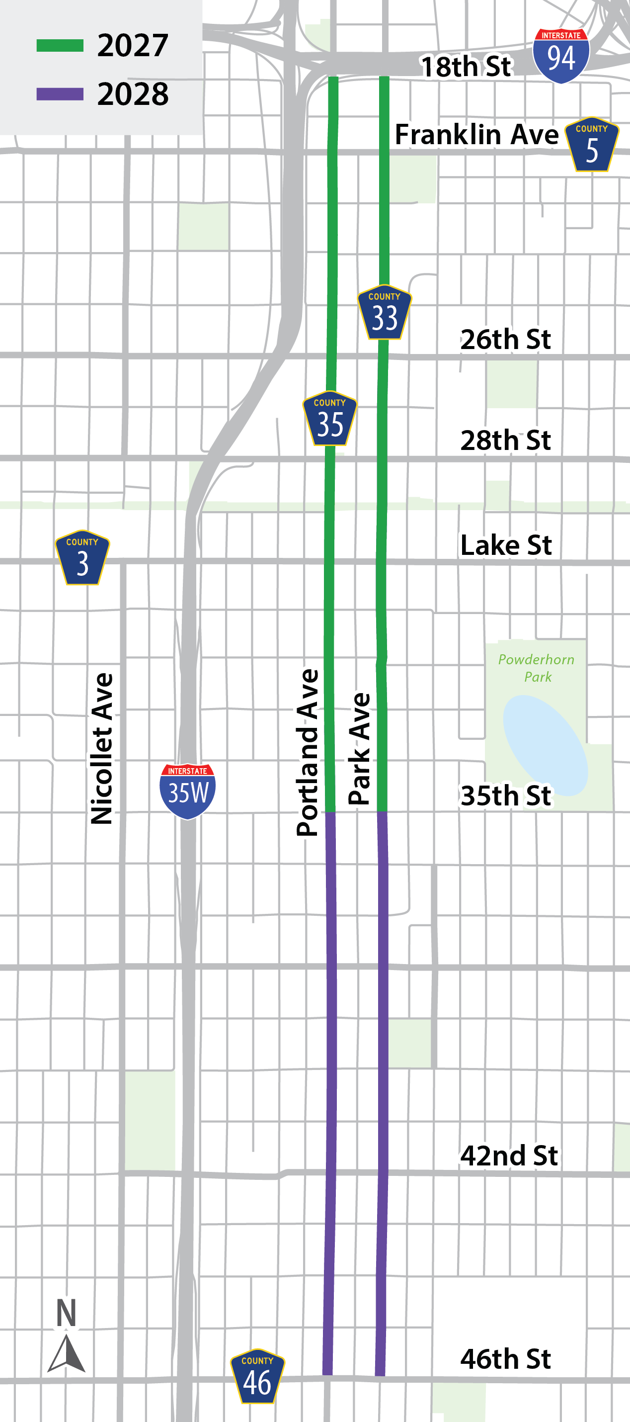
Construction along Park and Portland avenues is scheduled to begin in spring 2027. Construction will take place over two years with the final phase anticipated to be completed in 2028.

Starting in 2027
Crews will be working between E 18th Street and E 35th Street.
Starting in 2028
Crews will be working between E 35th Street and E 46th Street.
Commuting during construction
Here’s what you can expect during this two-year construction project. More information, including anticipated schedule and detour maps, will be provided prior to the start of construction in 2027.
Details are tentative and subject to change
If you drive:
- Construction will result in temporary traffic impacts on Park and Portland avenues.
- Local streets at intersections with no signals along Park and Portland avenues may be closed and detoured to support construction activities.
If you bike:
- Some bike routes may be rerouted during construction.
If you use transit, walk or roll:
Transit
- Buses may be temporarily rerouted as needed.
Walking or rolling
- You will still be able to move through intersections and access nearby properties.
If your home or business are within the project area:
- You will still have access to your home or business throughout construction
- Parking will be maintained in certain locations during construction
- Construction may affect how and where deliveries are made in the project area.
Próximas mejoras de seguridad en las avenidas Park y Portland
Desde 2024, colaboramos con los miembros de la comunidad para recabar opiniones sobre cuestiones de seguridad, prioridades e intersecciones que necesitan mejoras en materia de seguridad. Estos comentarios se incorporaron al proceso de diseño. El equipo del proyecto está ultimando los detalles del diseño. Se prevé que la construcción comience en la primavera de 2027.
Objetivos del proyecto:
- Mejorar la seguridad en las avenidas Park y Portland
- Mejorar los cruces de intersecciones para las personas que caminan, se desplazan en silla de ruedas o en otros dispositivos de movilidad y andan en bicicleta
- Crear espacios protegidos para andar en bicicleta
- Reducir la velocidad de los vehículos
Resumen de la construcción:
La construcción a lo largo de las avenidas Park y Portland está programada para comenzar en la primavera de 2027. La construcción se llevará a cabo durante dos años y se anticipa que la fase final se complete en 2028.

A partir de 2027
Las cuadrillas trabajarán entre E 18th Street y E 35th Street.
A partir de 2028
Las cuadrillas trabajarán entre E 35th Street y E 46th Street.
Desplazamientos durante la construcción
Esto es lo que puede esperar durante este proyecto de construcción de dos años. Se proporcionará más información, incluido el cronograma previsto y los mapas de desvíos, antes del inicio de la construcción en 2027.
Los detalles son tentativos y están sujetos a cambios.
Si conduce:
- La construcción ocasionará impactos temporales en el tráfico en las avenidas Park y Portland.
- Las calles locales en intersecciones sin semáforos a lo largo de las avenidas Park y Portland podrían cerrarse y desviarse para apoyar las actividades de construcción.
Si anda en bicicleta:
- Algunas rutas para bicicletas podrían desviarse durante la construcción.
Si usa el transporte público, camina o se desplaza en silla de ruedas u otros dispositivos de movilidad:
Transporte público
- Los autobuses podrían desviarse temporalmente según sea necesario.
Caminar o desplazarse en silla de ruedas u otros dispositivos de movilidad
- Aún podrá cruzar las intersecciones y acceder a las propiedades cercanas.
Si su vivienda o negocio se encuentra dentro del área del proyecto:
- Seguirá teniendo acceso a su vivienda o negocio durante toda la construcción.
- El estacionamiento se mantendrá en ciertas ubicaciones durante la construcción.
- La construcción podría afectar cómo y dónde se realizan las entregas en el área del proyecto.
Isbedelka soo socod ee horumarinta Wadooyinka Park and Portland
Laga soo bilaabo 2024, waxa aan la kaashanay xubnaha bulshada soo ururinta ra’yiga dadweynaha ee la xiriira amaanka, kala horumarinta, iyo baahida amaanka ee isgoysyada. Ra’yi dhiibashadaas waa lagu lamaaniyey nidaamka diyaarinta naqshadda. Shaqaalaha mashruuca ayaa dhameystiraya faahfaahintii ugu dambeysay ee naqshadda. Waxaa la filayaa in dhismuhu bilowdo xagaaga 2027.
Ujeedada Mashruuca
- Horumarinta nabadgelyada Wadooyinka Park and Portland:
- Horumarinta amaanka ka gudubka isgoysyada ee dadka lugeynaya, giraanta ku socda iyo bushkuleetiyada.
- Abuuritaan dhinac waddo ee amaan u ah bushkuleetiyada.
- Yareynta xawaaraha gaadiidka
Dulmar Guud ee Dhismaha:
Dhismuhu mashruuca Wadooyinka Park iyo Portland waxa uu bilaabanayaa xagaaga 2027. Dhismuhu waxa uu soconayaa muddo laba sano ah iyada oo la filayo in qeybta ugu dambeysa la dhameystirayo 2028.
La bilaabayaa 2027
Shaqaaluhu waxa ay ka shaqeynayaan inta u dhaxeysa Wadooyinka 18aad iyo 35 Bariga.
La bilaabayaa 2028
Shaqaaluhu waxa ay ka shaqeynayaan inta u dhaxeysa Wadooyinka 35aad iyo 46aad Bariga.
Isu socodka gaadiidka xilliga dhismaha
Halkan waxaa ku xusan waxyaabaha aad fili kartaan labada sano ee dhismaha mashruucu socdo. Macluumaad dheeraad ah, oo ay ka mid yihiin jadwalka iyo khadka ay marayaan gaadiidka xiliga wadooyinka la xiro, waxaa la soo bandhigayaa marka dhismuhu bilowdo 2027.
Jadwalka waa mid saadaal ku dhisan lana bedeli karo.
Haddii aad gaari wadato:
- Dhismuhu waxa uu saameyn ku yeelan karaa Wadooyinka Park iyo Portland.
- Waxaa suurogal ah in la xiro wadooyinka aan nalalka laheyn ee gudubka u jara Park iyo Porland in la xiro oo gaadiidka laga weeciyo si dhismuhu u hirgalo.
Haddii aad bushkuleeti ku socoto:
- Waxaa suurogal ah in khadadka bushkuleetiga wax laga bedelo mudada uu dhismaha socdo.
Haddii aad isticmaasho gaadiidka dadweynaha, lug ku socoto ama aad giraan raacdo:
Gaadiidka Dadweynaha
- Waxaa suurogal ah in khadka basaska wax laga bedelo hadba sida loogu baahdo.
Dadka lugta Ah/giraan ku socda
- Weli waad ka gudbi kartaa isgoysyada oo aad gaari kartaa dhismayaasha u dhowdhow.
Haddii gudigaaga ama goobtaad ganacsiga ay u dhow yihiin goobta mashruuca laga hirgelinayo:
- Weli waad gaari kartaa gurigaaga ama ganacsiga inta uu dhismaha socdo
- Goobaha gaadiidka la dhigto waa kuwo weli gaadiidka la dhigan karo meelaha qaarkood.
- Waxaa laga yaabaa in dhismuhu saameyn ku yeesho sida alaabada loo geeyo goobaha mashruuca.
-
Interim safety improvements coming in 2025

Hennepin County is planning to make safety enhancements on Park and Portland avenues (County roads 33 and 35) in 2027. However, based on community input and crash data, interim safety enhancements will be installed this fall at three intersections on Park and Portland avenues similar to the current project layout.
- Portland Avenue and 25th Street
- Park Avenue and 25th Street
- Park Avenue and 33rd Street
These interim modifications may inform future corridor design. Additional intersections may also be considered for interim safety enhancements in the future.
Mejoras de seguridad provisionales próximamente en 2025
El condado de Hennepin está planeando realizar mejoras de seguridad en Park Avenue y Portland Avenue (County Road 33 y County Road 35) en 2027. Sin embargo, con base en los comentarios de la comunidad y los datos de accidentes, se instalarán mejoras de seguridad provisionales este otoño en tres intersecciones de Park Avenue y Portland Avenue de manera similar al diseño del proyecto actual.
- Portland Avenue y 25th Street
- Park Avenue y 25th Street
- Park Avenue y 33rd Street
Estas modificaciones provisionales pueden orientar el diseño futuro del corredor. También se podrían considerar intersecciones adicionales para realizar mejoras de seguridad provisionales en el futuro.
Horumarinta nabadgelyada oo ku meel gaar ah ee 2025
Degmada Hennepin waxa ay qorsheyneysaa xoojinta nabadelyada wadooyinka Park iyo Portland (County roads 33 and 35) 2027. Hase yeeshee, iyada oo la tixgelinayo ra’yiga bulshada iyo xogta shilalka, waxaa wadooyinka lagu rakibayaa waxyaabo lagu xoojinayo nabadgelyada xagaagan isgoysyada Park iyo Portland taasoo la mid ah sida aad ku aragtaan naqshadda mashruuca.
- Isgoyska Wadada Portland iyo Wadada 25aad
- Wadada Park iyo Wadada 25aad
- Wadada Park iyo Wadada 33aad
Isbedelkaas ku meel gaarka ah waa mid u taagan isbedelka mustaqbalka. Waxaa kale oo suurogal ah in isgoysyo dheeraad ah lagu daro xoojinta amaanka ee mustaqalka.
-
Project update
Hennepin County is making safety improvements to Park and Portland avenues (County roads 33 and 35) between Interstate 94 and 46th Street East (County Road 46). The project aims to:
- Provide enhanced crossing opportunities for people walking, rolling and biking.
- Create safe, comfortable and convenient places for people biking.
- Implement design elements to calm vehicle travel speeds
The county values input from the public to inform the development of the new design for Park and Portland avenues. The project team has hosted a range of engagement events so far, including 11 neighborhood meetings, seven pop-up events and two public meetings. Through these events, we have collected your feedback on current conditions in the project area.
 Park and Portland listening session with Commissioner Conley
 Greenway Glow Ride, Summer 2024
Your feedback provided the project team with insights on which roadway elements could be used to achieve project goals. To improve safety, we assessed design options to increase visibility of people crossing intersections, protect people on bicycles from vehicle traffic and calm vehicle speeds. We aim to achieve these improvements while also minimizing impacts to on-street parking as well as adding more lighting and greening to the project area.
Along with your feedback, we used city and county policies and plans, and technical information to create a draft design concept for the corridor. You can view the draft design concept here.
We’ll collect feedback on the draft design concept throughout the spring of 2025. Then, we’ll use that feedback to create a final design that we’ll bring back to the public in late summer 2025.
-
Improving safety through design elements
Crash data from 2019-2023 demonstrates a clear need for safety improvements on Park and Portland avenues. In that five-year span there were 809 total crashes in this area, 75% happened at intersections while 25% happened between intersections. Of those crashes, 49 involved vulnerable roadway users (29 people walking and 20 biking), 23 serious injury crashes and one crash where an individual lost their life.
The project team evaluated different design options to make the corridor safer for people biking, walking and rolling. Learn more about these design elements:
Delineator-protected bike lanes
Delineator-protected bike lanes are bike lanes with plastic “bollards” (or “delineators”) that create separation between the bike lane and the vehicle lane. These types of bike lanes can help calm vehicle speeds and visually reinforce separation between vehicles and people biking.

Concrete curb protected bike lanes
 Example of on-street concrete curb protected bike lanesOn-street concrete curb protected bikes lines provide physical separation between vehicles and people biking. Curb protected bike lanes provide more protection for bikeways by enhanced separation between vehicles and bicycles and reducing vehicles encroaching into the bike lane.
Curb extensions
Curb extensions, or “bump outs”, are when the curb line is extended into the road at intersections. Curb extensions allow for the bikeway to transition to sidewalk level at intersections and create shorter crossing distances, protection for people biking, visibility of people walking, slower turning speeds for vehicles, narrows the road and provides opportunities for greening.
 Example of parking lane mediansPark lane medians
Parking lane medians are installed in the parking lane between the vehicle travel lane and the bike lane. This addition provides similar benefits as curb extensions such as shorter crossing distances, slower vehicle turning speeds, protection for people biking and calmer vehicle speeds.
Closed center median
Closed center medians are like regular center medians as they allow people walking and biking to cross the road in two phases and calm vehicle speeds by visually narrowing the traffic lane and requiring people driving to steer around them. Additionally, closed center medians prohibit vehicle traffic from crossing the road at a specific intersection, reducing the amount of vehicle traffic at that intersection as well as the number of conflict points between vehicles and all other people on the road. Closed center medians have curb cut outs that still allow people walking and biking to cross.
 Example of a closed center median
Finding these roadway elements in the current design options
The project team used curb extensions, parking lane medians, and closed center medians in the draft design concept. These elements are used throughout the draft design concept and offer safety improvements at intersections. The appropriate intersection treatment was selected by analyzing each intersection based on the following criteria:
- Number of people driving, biking, and walking
- Signalized or unsignalized intersection
- Proximity to activity centers
- Crash history
- Connection to the existing bike network
- Transportation disadvantage (Justice 40)
- Community priority
- Engineering judgement
Intersection treatment options


To provide a recommendation on the best way to improve safety for people biking on Park and Portland avenues we conducted technical analysis, consulted with partner agencies and considered public feedback collected to this point. All this data helped the project team provide the recommendation of concrete curb protected bike lanes to improve the safety of people biking in the project area.

You can view the draft design concept here.
We’ll collect feedback on the draft design concept throughout the spring of 2025. Then, we’ll use that feedback to create a final design that we’ll bring back to the public in late summer 2025.
